On Youtefa Bay, Jayapura, opening into the Pacific Ocean, spans the Youtefa Bridge at 732 meters long. It serves as then-president Joko Widodo’s first infrastructure project in West Papua, as part of the Trans-Papua road network, to ‘unite’ the nation through connectivity’. The bridge is at the epicentre of a multilayered series of socio-ecological problems, intertwining indigenous populations, the State, and the environment. Like in other colonised territories from occupied Palestine to Indigenous North America to Aboriginal Australia, infrastructure erases, reframes, and occupies. The Youtefa Bridge is a monument to settler-colonialist techno-power that perpetuates Indonesia’s imagination about West Papua–a land to be socio-ecologically extracted, integrating indigenous customary territories into its agglomeration of national development. In West Papua, infrastructure operates as Indonesia’s tool of social and physical terraforming; determining which of the landscapes, forms of life, agencies, and identities are possible within the Papua-Indonesia nexus. Paige West refers to this as autochthonous ideologies: rendering people, places, and times as static, exotic objects, while excluding anything dissonant. This process reduces Papuan identity into a monolithic mosaic piece within Indonesia’s brand of state multiculturalism—static beings, exotic creatures, and national assets waiting to be appropriated and commodified. These logics divide the West Papuan identity into finite governable units, dispossessing their agency over territory and resources. However this has contradictorily shaped West Papuan resistance into a generative refusal that has multiplied its specificities. In Jayapura, this refusal comes face-to-face with Indonesia’s most recent intrusion, the Youtefa Bridge. The bridge is a multiscalar and multilayered notion: from Youtefa Bay’s indigenous designation as a socio-ecological entity, Jayapura’s extended urbanisation, and a movement for West Papuan nationhood, it reveals the opaqueness of Indonesia’s territorialisation under the guise of development. Built by the government through the Ministry of Public Works between 2015 through to 2019, the million-dollar bridge towers over the bay and mangrove forest, inadvertently degrading local flora and fauna. The need for a bridge across the bay came out of Jayapura’s expanding urban sprawl and rugged terrain. The flatlands of Muara Tami district, bordering Papua New Guinea and serving as an agricultural transmigration enclave, offered a solution. The government saw this area as “an abundance of land spread … along the Koya area heading toward Skouw”, and prompted them to connect the two separate areas with a bridge, offering a ‘solution’ through land optimisation.
Sentinel 2 surface reflectance image of the Youtefa Lagoon on 2021-08-08 shows vegetated and inhabited barrier beach. Contains modified Copernicus Sentinel data 2021. European Space Agency. Via Wikimedia Commons
Jayapura city to Muara Tami connectivity Diagrammed from Google Earth
Youtefa Bridge extends from Pie Cape in Hamadi in the east to Ceweri Cape in Holtekamp in the west, and was constructed under a single infrastructural package. This route streamlines access from Jayapura’s urban core, reinforced by the formation of both peninsulas that provide an ideal site for efficient bridge and road construction. Youtefa Bay, located between Jayapura and Muara Tami, had “potential economic value”, motivating the government to designate it as the Rowing Venue for the 20th National Sports Week, the Indonesia–Papua New Guinea Border Crossing Post at Skouw, whilst also promoting tourism at Holtekamp beach. The bridge thus crystallises a new spatial logic: leveraging Jayapura’s growth, strategic peninsulas, shallow coastlines, and growing economy to spatially engineer Youtefa Bay, producing a technological framework imposed onto the bay’s intricate landscape to assert control against local needs. Youtefa Bay is then reduced to a legible grid, with mangroves and beaches framed as idle land, casting the bay with vacant possibility.
Youtefa Bridge and adjoining roads on Youtefa Bay Diagrammed from Google Earth
20-meter shift of the Holtekamp alignment PT PP (Persero) Tbk technical documents overlayed on Google Earth
Bridge spans elements being transported Official Joko Widodo Youtube Channel
Mangrove area changes 1994-2017 Hamuna and Tanjung, overlay on June 2017 Google Earth
Reconstruction of the flag of the ‘Koreri’ resistance movement of West Papua against Japan in World War II Wikimedia Commons
Papuan resistance traces its roots to a centuries-old refusal of subjugation. Beginning in the 1850s, such consciousness had already begun to manifest with the emergence of the Koreri, a movement formed in refusal to foreign occupation. Over time Koreri gradually became a proto-West Papuan nationalist movement, marked by an early 1930s uprising led by a woman named Angganitha Menufandu, which was a direct resistance against Dutch colonialism, a system that positioned Papuans at the lowest stratum of the colonial hierarchy. This legacy of defiance crystallised into self-determination and sovereignty of their own world-making, symbolised by the Morning Star flag: a cosmopolitical emblem linking the memory of the Koreri Movement, the global Free West Papua anti-colonial struggle, anti-racism solidarity, trans-indigenous refusal, and broader networks of liberation culminating in the declaration of West Papuan independence on 1 December 1961. Despite Indonesia’s annexation, resistance deepened and was moved from the coast towards the territory’s remote highlands. The Arfak Uprising in 1965, along with other regions, declared armed resistance against any colonial power, both Dutch and Indonesian, became a momentum for coastal-highlands resistances and ignited a protracted struggle for liberation that continues to echo across generations through the Free Papua Movement.
Free West Papua Graffiti in London Matt Brown, Flickr
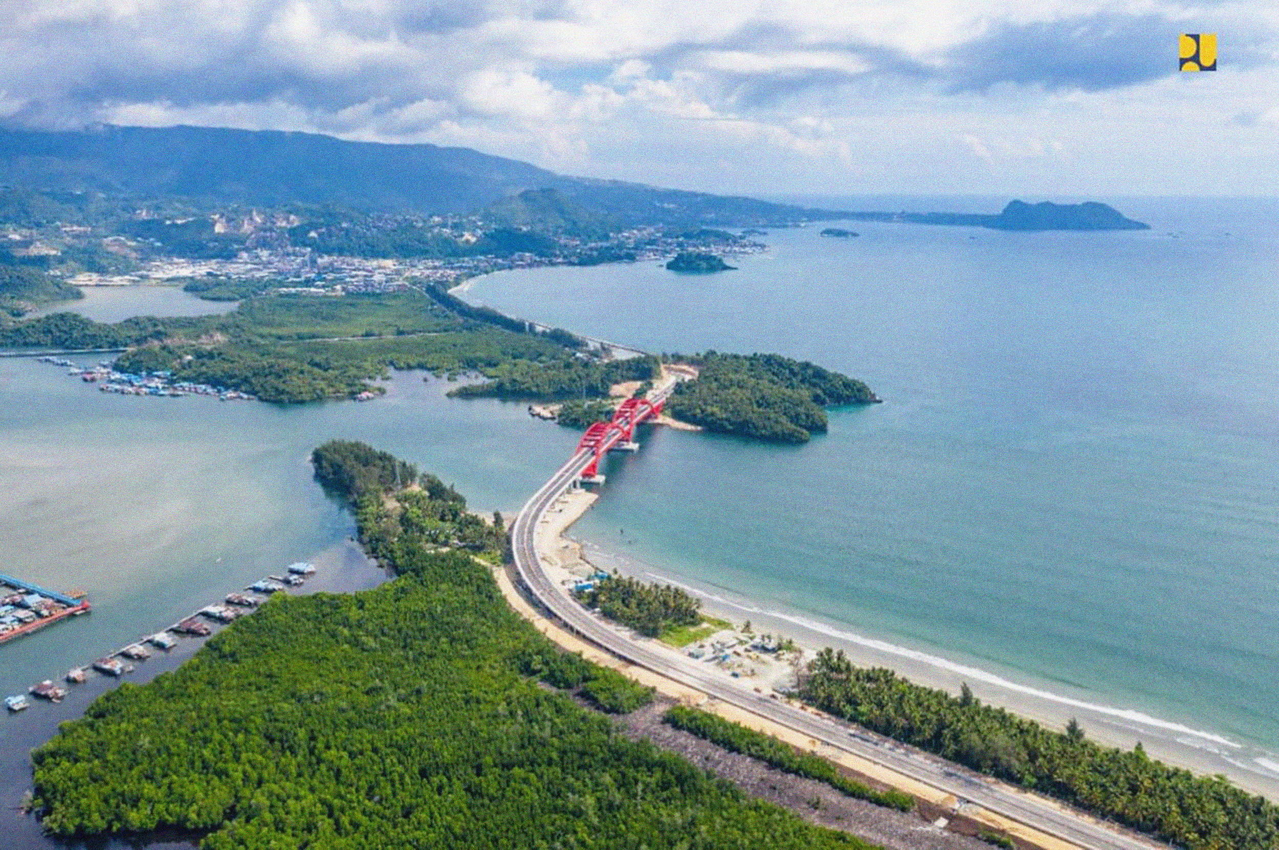
Aerial view of Youtefa Bridge Ministry of Public Works and Housing of Indonesia
President Joko Widodo inaugurating the Youtefa Bridge in Jayapura City, Papua Province, on Monday, October 28, 2019. Official website of the President of the Republic of Indonesia