Sedimentology and geochronology
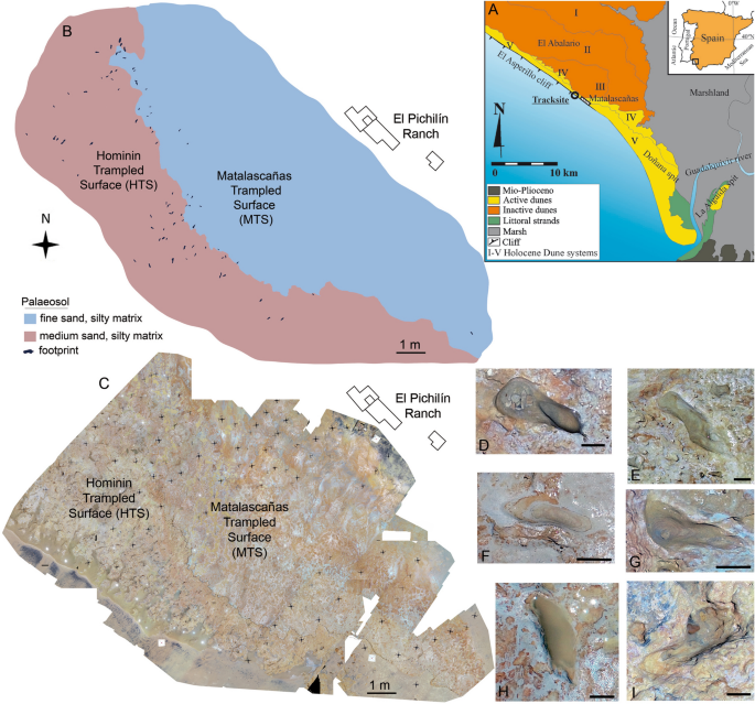
The stratigraphic sequence of El Asperillo Cliff was previously defined by previous authors16 and consists of a series of Pleistocene units interpreted by these authors as aeolian bodies. These units are named starting at the base: U1, U2 and U3. Each unit is separated from the others by bioturbated fine-grained beds, interpreted as pedogenic levels, paleosols or lacustrine beds. These palaeosols are ussually rich in clays and organic matter, but can also have a ferruginous composition. The lowermost pedogenic level PS128, located immediately under U1, is characterised by yellowish-reddish mottled colours and an extensive network of polygonal mats of at least 300 m in length, which is the maximum surface area exposed so far (Fig. 7) which preserves both hominin fossil footprints6 and other associated vertebrate tracks13,14,15. Medium-fine sands form PS1 with a silty matrix (sample PS-2/0.3 m) displaying a strong vertically elongated arrangement of mottling, suggesting a genetic relationship with plant-root activity28. The top of this level presents a significant irregular surface with a millimetre-scale ferruginous crust which imprints the tracks. This surface slightly slopes to the SW. PS1 was OSL-dated (Sample M1) and yielded an age of 295.8 ± 17.8 ka (Table 2).
Figure 7 Current intertidal zone in the area surrounding El Pichilín, Castilla beach, Matalascañas. (A) General view of the cut-wave platform. Scale bar: 50 m. The polygonal mats with upturned margins of individual polygons show an extensive open cracks network resulting in the saucer-shaped polygons. Locally, subcircular openings with upturned and curled margins of the thin mat can also be seen. (B) Detail of the NW sector. Scale bar: 2 m. (C) Detail of the SE sector. Scale bar: 1 m. (D) Cervipeda and undetermined tracks were preserving remains of the microbial mat trapped under their footprints. Scale bar: 8 cm. (E) Hominin footprints preserved on the polygonal mats. Scale bar: 20 cm. The photogrammetric orthomosaic (A) was produced using Pix4DMapper© (versión PIX 4D Cloud, https://www.pix4d.com/). (A) was obtained by a low-altitude programmed flight using an Unmanned Aerial Vehicle (UAV) on June the 12ht, 2020, 12 AM UTC. Photograph was collected by a multirotor DJI Phantom 4 + with a 4 k 20 Mpix RGB CMOS camera at an average height of 50 m above the ground. Full size image
Unit U1 consists of three different sandy bodies (Fig. 2). The lowest is composed of moderately-sorted fine sands (sample U-1/0.7 m, dating sample M2-3, age 274.0 ± 15.8 ka, Table 2). The internal ordering of this body presents a base constituted by sets of hummocky cross lamination that evolve to parallel lamination slightly tilted to the NE. This first body results from strong water currents as indicated by the presence of hummocky cross-bedding. The second body of U1, constituted by moderately poorly-sorted medium sands (Sample U1/1.5m, dating sample M2-2, age 232.8 ± 13.1 ka, Table 2), presents an erosive base that cuts the lower body neatly and a clear planar crossbedding tilted with a NE vergence. A new erosive and bioturbated surface cuts the top of this crossbedded set. This second body was deposited under landward flows. The presence of land-inclined metric planar cross-bedding suggests being originated from a migrating aeolian dune. The third body of U1 is a metric level of parallel laminated well-sorted medium sands. This level is the top of U1 and could represent a set of parallel lamination similar to the deposited in an aeolian plane sheet. The entire sequence of U1 is similar to the typically developed in a dune field. At the top of the sequence of U1, a new pedogenic level with less entity than PS1 is present. This is a 10 cm sandy mud level with traces of plant bioturbation. The interpretation of U1 agrees with the vision of previous authors16, who suggest a dune origin for these facies.
From unit U2, only the base was analysed in this study. This basal body consists of a metric set of convolute laminated fine sands with significant amounts of very fine sands and silts (Sample U2/3.5m, dating sample M3, age 203.8 ± 12.7 ka, Table 2). The top of this body presents an irregular surface, including flame and charge structures, indicating fluidised sediments injection into the sandy upper body. The presence of these structures indicates an apparent water saturation of sediments during an earthquake. The upper bodies of U2 were not analysed, but they are described in the previous papers6 as well-sorted fine sands with complex curved-base cross-stratification. These upper bodies of U2 appear to be aeolian dunes as interpreted by the previous authors16.
Palaeoenvironmental framework
The new chronology allows us to place the surface with hominin and other vertebrate footprints in the transition between MIS 9 and MIS 8 (295.8 ± 17.8 ka). Since then and until the Holocene, several stadials and interstadial periods have followed one another. Cold and dry climates characterise these stadials in the centre of the Iberian Peninsula and especially in northern Europe. However, the coastal areas of the Gulf of Cadiz served as reservoirs of thermophilic plant communities in these cold periods, favouring the settlement of human populations29. This would indicate a more temperate and humid climate, with high phreatic levels, abundant vegetation and edaphic and/or lagoon development. This new scenario contrasts with the previous geodynamic and chronological paradigm established16,28, which determines a wetter landscape in the interstadial periods, with edaphic development, and a drier landscape in the stadial periods, where dune dynamics dominate. This does not agree with the sedimentary record studied and the new chronology proposed in the present paper.
The sedimentary sequence outcropping at the Asperillo cliff shows a succession of beach-dune episodes and edaphic and/or pond surfaces, with sedimentary facies associated with the dynamics of the pond and tributary streams when aeolian activity ceased. The series above the Hominin Trampled Surface (HTS) starts with a dune deposit during MIS 8, with a direction of advance towards the E and ESE. During the last phases of MIS 9 in transit to MIS 8, the sea level would be, according to the composite sea-level curve for the Pleistocene epoch30, about 60 m below the present sea level, which would imply a shoreline position 20–25 km away from the present position. In this scenario, a very extensive coastal plain would develop with large flooded areas in shallow and hypersaline lacustrine environments. In this sense28, believe that from a stratigraphic point of view, the palaeosol PS1 represents the surface of an ancient fluvio-deltaic coastal plain so that the exposed palaeosols correspond to the same pedogenic cycle, which would have acted in the zone prior to c. 100 ka BP during the Middle-Late Pleistocene transition. This environment could be covered by water during humid seasons and totally or partially exposed during dry seasons. As a result, polygonal mats characterized by wide cracks with upturned margins producing individual saucer-shaped polygons were formed (Fig. 7A–C) and trampled, both by hominins and the rest of the vertebrate faunas (Fig. 7D,E). Currently, such networks of polygonal mats are found in extensive areas of tidal flats in both hot desert climates31,32 and tropical33 climates.
In the non-flooded areas of this broad coastal plain hydromorphic processes related to root activity developed, constituting more or less extensive vegetated zones. The pedofeatures of the PS1 indicate, according to28, a long period of soil development related to a well-developed plant cover living on mature soils. Around these areas would expand a significant development of dune systems moving landward from the coast, similar to during the Holocene climatic optimum16. High sea positions and interstadial periods would favour this development of dune systems (Fig. 8).
Figure 8 Proposed palaeoenvironmental context of Matalascañas and the evolution of the dune deposits about the rise and fall of sea level are presented. Full size image
As the sea retreated during MIS 8, the coastal plain would continue to expand by several tens of kilometres. The most active dune sequence would accompany this marine retreat, confining itself to the outermost coastal area. In a cooler and wetter climatic context, the former MIS 9 dunes would remain inland and progressively colonised by vegetation. The wind systems would be stabilised by vegetation, with edaphic development and pond proliferation in the topographically lower areas, with associated sedimentary facies due to surface water dynamics. We must not forget the hydrogeological conditions of the sandy substratum favouring the contribution of phreatic water to the wetland mosaic.
The series above the Hominin Trampled Surface (HTS) starts with a stream deposit during MIS 8. The sand bodies display a direction of advance towards the E and ESE. During MIS 7, the new sea rise would result in a further beach-dune advance landward, fossilising the soil and lagoon surfaces, in the context of a more significant aeolian activity, which would be interrupted by the wetter episode of MIS 7d and the subsequent drop in sea level. After that, the warmer phase of MIS 7a, b and c and the consequent rise in sea level would be accompanied by a new episode of aeolian activity, which ended during MIS 6.
In the El Asperillo Cliff area, the study of pollen levels corresponding to the cold periods of the Pleistocene would indicate a wetter and colder climate than the current one, with the presence of palaeochannels freshwater environments34. The pollen record from El Asperillo in the initial phases of the last glaciation reinforces the refugial character of these areas for Euro-Siberian and Atlantic taxa during the cold stages34,35. Similarly, in other areas of the eastern Iberian Peninsula, the influence of the Mediterranean Sea may have played an important role in attenuating the extent of this climatic deterioration compared to other inland regions of the Iberian Peninsula36. Thus, coastal areas must have reflected a landscape that offered a broad and constant spectrum of possibilities for past human populations.
Taxonomic and palaeoanthropological implications
The new chronology at Matalascañas indicates that the human footprints would have been made nearly 200,000 years prior to the time established in their initial study6. This chronological shift places these new footprints during the Middle Pleistocene, specifically at the transition between MIS 9 and MIS 8. This new context is relevant since it provides information about the Middle Pleistocene fossils, a fragmentary and geographically heterogeneous record (Fig. 9), attributed to taxa belonging to the Neandertal lineage (i.e. to Homo neanderthalensis or Homo heidelbergensis s.l.). Footprints are even more scarce than skeletal remains in the entire European Middle Pleistocene since only four sites have delivered footprints from this period: Terra Amata37 and Roccamonfina4, dated to 380,000 and 345,000 years ago, whose footprints were attributed to Homo heidelbergensis, and the sites of Biache-Vaast12 and Theopetra7, dated to 236,000 and 130,000 years ago, whose footprints were attributed to Homo neanderthalensis. The dimensions of these Middle Pleistocene footprints are known except for the one from Biache-Saint-Vaast. The length ranges of the Matalascañas footprints (14–29 cm6 include those of the other sites. The two footprints measured at Theopetra (14–15 cm7 are close to the shortest Matalascañas footprints in contrast to the footprints from the Roccamonfina trackways (24–27 cm4 and the Terra Amata footprint (24 cm37). In particular, evidence of human occurrences dating to MIS 9 and MIS 8 is extremely rare38. They are mainly known from archaeological material (e.g. lithic industry, hearths, faunal remains), including some occurrences in the Iberian Peninsula39, such as at Bolomor Cave40 or Loma de los Huesos41 (Supplementary Table S1 online). European palaeoanthropological record (hominin skeletons and footprints) from these stages is much more scarce than archaeological material. Except for the Matalascañas footprints, no other hominin footprints from MIS 9-MIS 8 are known (Supplementary Table S2 online).
Figure 9 Geographical distribution of the main palaeoanthropological sites for the European Middle Pleistocene. Only those containing skeletal and ichnological assemblages are represented. The map was created from a free template (https://commons.wikimedia.org/wiki/File:Europe_satellite_image_location_map.jpg). The legends were added using Inkscape (v.1.0.2, https://inkscape.org/). Full size image
On the other hand, the number of paleoanthropological remains is reduced for the MIS 8 (Supplementary Table S1 online). Within the Iberian Peninsula, the footprints from Matalascañas are, to our knowledge, the only palaeoanthropological remains dating from MIS 9 or MIS 8 that have been published.
The taxonomic attribution of the Matalascañas footprints has to be discussed in light of the new dating. Indeed, in their initial study, they were attributed to Neandertals based on the first dating estimated at 106 ± 19 ka by16 in6.
This method of taxonomic attribution based on chronological context is common for hominin footprints. Indeed, ichnotaxonomy, usually used in the study of dinosaur tracks, is very little for hominin footprints. The ichnotaxon Hominipes modernus9 can include all known footprints attributed to the genus Homo by its diagnostic characteristics: from Ileret footprints potentially made by Homo ergaster or Homo erectus l.s.42 to the most recent Homo sapiens footprints. This inability to differentiate between human species constitutes one of the limitations of ichnotaxonomy in palaeoanthropology, at least for the most recent species that are best known from skeletal remains.
Furthermore, the taxonomic attribution of hominin footprints can be supported by geometric morphometry studies highlighting the anatomical features of the track-maker foot2,43. For instance, the attribution of footprints discovered at Le Rozel (80 ka, France) to Neandertals was supported by morphological differences between these footprints and those made by H. sapiens. The Le Rozel footprints were wider, especially at the midfoot level, reflecting a more robust foot and a less pronounced longitudinal arch2, anatomical characteristics known in the Neandertals fossil record44,45. However, such anatomical inferences are a challenging task, as the morphology of the footprint does not only result from the anatomy of the foot but also other factors such as biomechanical characteristics, the type of substrate or taphonomy. Therefore, the studied footprints must be well preserved and reflect several anatomical features (toe impression arch), which is rarely the case in loose substrates, such as the Matalascañas, where morphological variation is very important46.
If anatomical features can be obtained from the Matalascañas footprints, it will be necessary to compare them to the known Middle Pleistocene skeletal record to support a taxonomic assignment. Unfortunately, this record is scarce and heterogeneously distributed, spatially and temporally (Supplementary Table S1 and S2 online). Almost all of the known foot fossils for that period are from the Sima de Los Huesos site (SH, Spain) and are associated with Neandertal-related individuals47,48,49,50. Nearly 500-foot bones have been discovered at SH. The foot fossils show a robust overall morphology with large facet joints, recalling those of the Late Pleistocene Neandertals51. However, still, they show some differences from Late Pleistocene Homo species, such as a particularly projected sustentaculum tali for calcanei, a vertically short body, broad fibular facets, and a mediolaterally broad talar head for tali that make this a distinct morphology for this Middle Pleistocene population50,51. However, these features are probably too tenuous to discern from the morphology of footprints compared to Late Pleistocene Neandertal populations.
On the contrary, the base of the Sima de los Huesos metatarsals is wider than that of the Neandertals, indicating a wider midfoot50. Such a difference might be detectable from the footprints. If the individuals who made the Matalascañas footprints were morphologically close to those of SH, their best-preserved footprints could be wider than Neandertal and Homo sapiens footprints left in similar substrate conditions.
The foot fossil record of other Middle Pleistocene European with chronologies similar to SH is not abundant. It is restricted to the fragmentary second metatarsal discovered in Arago (France) within abundant skeletal material associated with Homo heidelbergensis or Homo erectus tautavelensis52. This isolated second metatarsal described as not very robust53 does not allow for inference of the foot's morphology and, therefore, the resulting footprints. More recent (MIS 10-6) published remains comprise the second metatarsal from Sedia del Diavolo (MIS 854) and a talus from Grotta del Poggio (MIS 7-655), which are insufficient to ascertain the potential morphology of the footprint of the hominins of these chronologies.
Therefore, the results from50,51 show slight differences in the foot morphology within the Neandertal lineage. However, the scarce Middle Pleistocene fossil record for this anatomical region currently does not allow us to know when the “SH foot” became a Late Pleistocene “Neandertal foot” and whether these slight morphological differences would result in ichnological differences is still to be proven.
Therefore, taxonomic attribution is based only on chronological context, as is the case for most hominin footprints. The Middle Pleistocene European hominin fossils belong to the Neandertal lineage, either Neandertals or Homo heidelbergensis s.l. Therefore, the most likely taxonomic assignment for the Matalascañas footprints would be one of the taxa within this lineage. However, a more precise attribution seems complicated as there are many debates about the evolution of this lineage but also about the taxonomic definition of Homo heidelbergensis. Different models have been proposed for the evolution of the Neandertal lineage (e.g.,56 and references therein). This matter is still far from being solved, given the paucity of the fossil record and the new, more complicated evolutionary picture provided by the latest ancient DNA studies (e.g.,49). Based on the craniodental features, the pre-MIS 10 fossil record shows a great hominin morphological diversity with some demes (such as SH) morphologically and genetically linked to Neandertals47,48,49, while others (such as Aroeira, Ceprano or Mauer) show more primitive features38,57,58.
Additionally, it is possible to ascertain that not all anatomical features evolved at the same rate and that the Middle Pleistocene fossil record probably showed polymorphisms in different features with different percentages of appearance47,48,59. For example, despite its small size, the SH dentition is very Neandertal like60,61, but this deme shows a primitive occipital morphology and different morphotypes in the maxillary and radial morphology. The post-MIS 10 European fossil record shows, in general, an increasingly more “classic Neandertal” like morphology (e.g., Biache-Saint-Vaast62 but see63). Some of the MIS 7 fossil remains (such as Ehringsdorf) are regularly referred to as old Neandertals, but some fossil remains, such as the Montmaurin mandible64 and the Payre mandible65, document the persistence of plesiomorphic features even for these more recent periods. The latter could also reflect the aforementioned mosaic pattern of evolution in which some anatomical regions evolve at different rates.
In summary, based on the current knowledge of the human fossil record in Western Europe and the Iberian Peninsula in particular, and the new dating for the site, we consider the attribution of the Matalascañas footprints to individuals from the Neandertal lineage to be the most parsimonious decision. However, better-preserved footprints, in which Neandertal features such as a relatively wide foot, were noticeable would be necessary to test this hypothesis. On the other hand, studying the footprints can provide important palaeobiological information. Indeed, the first study of these footprints revealed that they were made by at least three individuals, including one child aged 6–8 years, probably seeking or bringing back resources, the orientation of these footprints towards animal tracks could indicate hunting behaviour6 a communal activity also detected in level TD10 of Gran Dolina, Atapuerca66. Furthermore, a child's participation in subsistence strategies could provide unique information about the distribution of activities within hominin groups and the cognitive learning of these activities. Indeed, although more and more archaeological discoveries have documented the complexity of subsistence strategies during the EMPH67,68, younger individuals' roles (learning, active participation) are currently unknown. Knowledge of these roles would provide unique information about these Middle Pleistocene hominins’ cultural and social behavior.