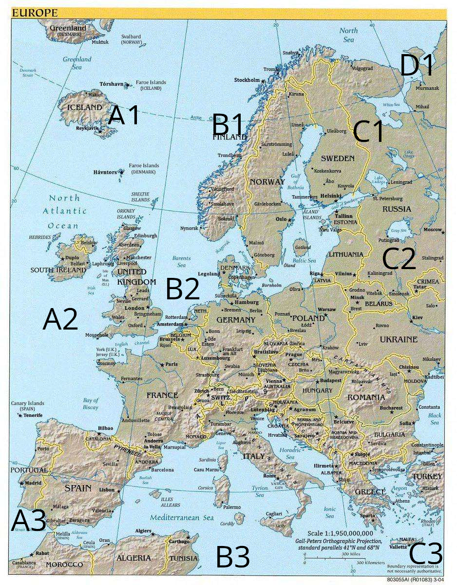
I recently came across this map of Europe in a Discord memes channel:
At first glance, it didn’t seem to be anything special, but why was it posted in a memes channel? I took a closer look. Even if you’re not super familiar with European geography, you’ll probably find something… off about it. Or many things.
After finding a lot of discrepancies from my own memory of European maps, I decided to try to catalog every single problem with the map and found way more issues than I expected. I think it’s very likely I missed some things as well, so please email me if you find more issues. I’ll update the list and give you credit (or keep it anonymous if you’d prefer).
To make it a little easier to see where each issue is, I’ve marked the map according to the grid made by the solid latitude and longitude lines:
(Pardon the low quality, the original I saw was already riddled with JPEG artifacts.)
The “solution”
A1
“Muktuk” is not a city in Greenland
Svalbard is a real place, but it’s directly north of Norway (and much farther north). The island marked as Svalbard is called Jan Mayen
Iceland is rotated 180 degrees
“Faroe Islands (ICELAND)” don’t exist
The arctic circle doesn’t pass through Iceland (though this may be a consequence of the rotation)
Reykjavík is in the wrong place on the island anyway
The capital of the Faroe Islands is Tórshavn - it’s correct on the fake islands, but wrong on the real ones
Havntors isn’t a real place
The “Sheltie islands” are actually called Shetland or the Shetland islands
A2
Glasgow, Edinburgh, Manchester, Liverpool, London, Belfast, and Oxford are all in the wrong place (Aberdeen and Mousehole are the only correctly placed and named cities in the UK)
Laphroaig is not a city in the UK (although it is correctly placed)
Leeds is misspelled as Leads (although it would be in the right place)
There is no city named Gerrard
Neville is a city in France, but not the UK
Bringmeham, UK doesn’t exist (probably an intentional misspelling of Birmingham)
Wales is a country in the UK, not a city (though it’s in roughly the right place)
The island marked “York (U.K.)” is actually called Guernsey
Belfast, UK is listed as “Belslow”
Ireland is called South Ireland instead of just Ireland (a reference to the country in the UK called “North Ireland”)
Dublin, Ireland is listed as “Belfast”
Duplo, Ireland doesn’t exist (and Dublin should be marked as the capital)
There’s no “Goscinny” in northwestern France
Nantes, France is called “Fernantes”
The Canary Islands are off the coast of Africa, not northwest of Spain
The capital of the Canary Islands is called “Santa Cruz de Tenerife”, and is abbreviated as “Santa Cruz”, not “Tenerife”
Catalonia is not an independent country. The part marked as Catalonia is roughly in the location of Basque Country, an autonomous region of Spain
Sevilla is in the wrong place
A3
Lisbon should be where “Madrid” is marked in Portugal
Madrid should be in central Spain
Málaga is northwest of where it should be
Valencia is farther south than it should be (it should be roughly where “Lisbon” is marked)
Zaragoza is in northeast Spain, not on the southern coast
Melilla and Ceuta are swapped (and Ceuta might be misspelled as Ceula)
The sea between Spain and Morocco is called the Alboran Sea, not the Alderaan Sea
Rabat looks too far north (although that could be a projection problem)
Casablanca is part of Morocco, not France
B1
The country marked as Finland is actually Norway
The country marked as Norway is actually Sweden
Stockholm is the capital of Sweden and should be where Oslo is marked (in B2), not in the north
Tromsø is a region of Norway, not a city
Trondheim looks like it’s marked too far northeast
“Vikingfjord” and “Smalahove” aren’t cities
“Surströmming” is the name of a food, not a city in Sweden
“Gävlebocken” placed where “Gävle” should be.
B2
“Bokmål” and “Nynorsk” aren’t cities
Oslo is in Norway, not Sweden. On this map, it should be placed where Bokmål is, and is placed where Stockholm, Sweden should be
Göteborg should be farther north on the coast
Malmö should be farther south on the coast
Gotland should be smaller
Sweden’s borders should extend to the end of the peninsula
Copenhagen should be on one of the islands of Denmark, not on the Swedish peninsula
Copenhagen should be marked as the capital of Denmark, not Legoland (which isn’t a city, obviously)
“Sübeckißa” doesn’t exist
Hamburg isn’t the capital of Germany
Berlin is the capital of Germany
Öde doesn’t exist
Essen is north of Bonn
Frankfurt is short for “Frankfurt am Main”, not “Frankfurt am Alt”
Swabia is a region of Germany, not a city
Strasbourg is in France; it should be just over the border of where it is on this map
Rotterdam and Amsterdam have their locations swapped
Luxembourg is much bigger than it should be
Rijsel is the Dutch name for Lille, France (not that this is “wrong”, it’s just not the primary name for the city)
Beaujolais is a region of France, not a city
Toulouse is listed as Tolose (possibly an alternate spelling, or another language’s name for the city)
“Marsupial” isn’t a city
Oliwa, Poland is listed under its Latin name, Oliva
Wrocław, Poland is listed under its German name, Breslau
Slovakia and Czechia have their shapes and locations swapped (this also changes the borders of the surrounding countries)
Bratislava and Prague (the capitals of Slovakia and Czechia) are in the right places within their borders, but are obviously in the wrong absolute locations
“Žinčica” is not a city
“Mrs” is not a city
Slovenia doesn’t border Germany, Slovakia, Czechia, and Austria; it should be farther south, bordering Italy, Austria, Hungary, and Croatia
The capital of Slovenia is Ljubljana, but it obviously shouldn’t be where it is due to the switch listed above
Austria is listed as “Australia”
Zürich, Switzerland and Bern, Switzerland have their locations switched, roughly
Zürich isn’t the capital of Switzerland, Geneva is…
Geneva, Switzerland is switched with Genoa, Italy (which is an Italian city with which it shares etymology)
There’s a fictional country called “Molvania” where Slovenia should be
Florence, Italy is where Milan should be
Turin, Italy is listed as “Turambar”
Florence, Italy is listed as “Alighieri”
Rome (and Vatican City) is farther south on the coast than it should be, occupying roughly the spot of Naples
The names of the islands Corsica and Sardinia are swapped
“Casu Marzu” isn’t a city
Andorra is much larger than it should be, cutting into Spain significantly
Bosnia and Herzegovina is listed as “Serbia and Montenegro” which are independent neighboring countries
Zagreb, Croatia is listed as Agranum (its Latin name)
Hrvatska is the name of Croatia in Croatian, not a city in Croatia
Montenegro is missing (see C2 for more)
Tirana, Albania is listed as “Ilirmeta”
Shqip is the name of Albanian in Albanian, not a city in Albania
B3
Cagliari and Palermo, Italy, are swapped
The Balearic Islands are listed as “Illes Allears” instead of “Illes Balears”
Cordily (an island in the Mediterranean) doesn’t exist
The second number in the scale is 100x what it should be (comparison)
The numbers for the parallels are probably wrong too
I don’t think the projection is actually the Gall-Peters Orthographic Projection
Algeria isn’t as wide as it should be, bringing Tunisia farther west than it should be
The capital of Tunisia is marked as “Carthago”, when it should be Tunis
Malta is missing (see C3)
C1
Volgograd should be west of Ukraine, outside the scope of this map (it possibly should be listed as Murmansk)
Oulu, Tampere, and Turku are listed by their Swedish names (Uleåborg, Tammerfors, and Åbo, respectively)
Tampere and Turku (Tammerfors and Åbo) have their locations swapped
Lulea and Umea, Sweden are switched
“Koskenkorva” is not a city
Leningrad is the former name of St. Petersburg, not a city to its northwest
C2
“Viru Valge” is not a city
Lithuania is expanded to take over Latvia as well
Kaliningrad is listed as Latvia instead
Because of the above, Riga, Latvia is placed within Kaliningrad
Putingrad doesn’t exist
The Gray Sea doesn’t exist
Kaliningrad, Russia should be between Poland and Lithuania, not within Russia’s main borders (see above)
Most of Belarus is eaten by Russia
Smolensk, Belarus is farther south than it should be (it would be within Belarus’s borders on this map)
Vitebsk, Belarus is farther south than it should be, keeping it within Belarus
Hrodna, Belarus is listed under its Polish name, Grodno
Minsk, Belarus is farther southwest than it should be
Crimea is a peninsula on the south side of Ukraine (which has been occupied by Russian invaders since 2014), not a country to the north of Ukraine
Tatar is not a city in the fake Crimea on this map. The Tatars are a Turkic ethnic group of which a significant population lives in the real Crimea
“Salo” is not a city
Rivne and Mykolaiv, Ukraine are listed under their former Russian names (Rovno and Nikolaev, respectively)
Kadstbei doesn’t exist
Moldova’s borders stretch to the Black Sea, cutting into Ukraine
Cluj-Napoca, Romania is listed under its Hungarian name (Kolozsvár)
Magyarország is the name of Hungary in Hungarian, not a city in Hungary
Serbia is listed as “Bosnia and Herzegovina” (see B2 for more)
Kosovo isn’t shown (perhaps due to its incomplete recognition by other countries)
Belgrade, Serbia is listed as “Belcurve”
Bulgaria’s borders cut north along the Black Sea into Romania’s, making it landlocked
Varna, Bulgaria is listed as “Sofia” which is the capital–so Sofia should be marked as the capital, but not where it is
Sofia, Bulgaria is instead marked as “Serdica”
Macedonia extends southeast, cutting into Greece significantly
Thessaloniki, Greece is listed under its nickname “Symprotévousa”
Constantinople is a former Roman name for Istanbul, not a separate city on the other side of the Bosphorus
C3
Athens, Greece is on the wrong peninsula
Sparta is not the capital of Greece (and is now romanized as Sparti)
“Gülen” isn’t a city in Turkey
“Atatürk” isn’t a city in Turkey
The island of Crete is listed as Malta
Rhodes, Greece is listed as an Italian territory
The Aegean sea is listed as “Aegon”
D1
The city listed as Murmansk is probably Dolgoschel’e (see C1)
Arkhangelsk is listed as “Mihail”
P.S. I have no idea what the original source of this map is. If you happen to know, please tell me!