Pop-up archival satellite tags (PSATs)
All eels were equipped with an X tag from Microwave Telemetry (www.microwavetelemetry.com) which is 120 mm long, with a 185 mm long antenna. The maximum diameter of the float is 33 mm. Weight in air is 45 g and net buoyancy in seawater is approximately 0.025 ± 0.006 N, corresponding to a negative weight of 2.6 g. The tag measures and stores pressure, temperature and light data every 2 min. A subset of these data are transmitted when the tags pop up at either a predetermined date or if any of the fail-safe devices are triggered, for example if a critical pressure is exceeded. The temperature measurement range is − 4° to 40 °C with a resolution of 0.23 °C. The depth range is 0 to 1300 m with a resolution varying between 0.34 and 5.4 m depending on the gain value which is automatically selected according to the depth measured at midnight each day. The time of release was programmed at 6 months (n = 10), 7 months (n = 10) or 1 year (n = 6) after deployment. The constant pressure release feature that detaches the tag if the depth reading remains within 3 m for a period of 4 days was deactivated for the first 20 days after deployment to avoid premature release with limited movements in shallow water. After a tag pops up, surface position and a time series of depth and temperature are transmitted from the tag to low Earth orbiting ARGOS satellites (http://www.argos-system.org/) from where they can be downloaded. More details on how data from the tag are coded and transmitted can be found at https://www.microwavetelemetry.com/data. The surfacing positions of tags that drifted at the surface before activating their communication with the ARGOS satellite system were back-calculated by determining the direction and velocity of surface currents observed after the tag’s first ARGOS transmission over the same period of time as the surface drift period.
Eel capture and tagging
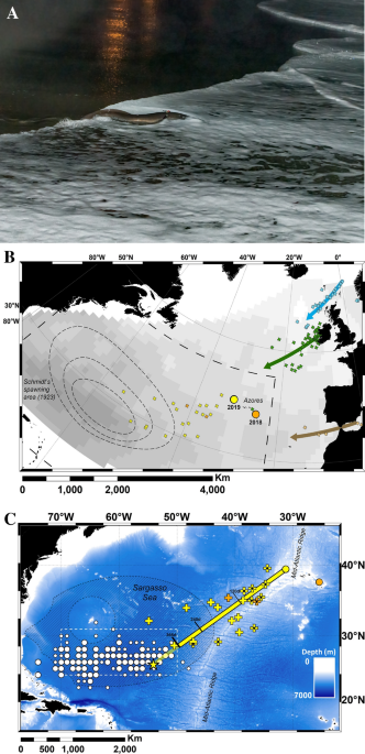
Wild adult ‘silver’ eels were captured during their Autumn downstream migration using fyke nets set in the freshwater reaches of rivers on the Azorean Islands of San Miguel and Flores. There is no commercial eel fishery in the Azores and very little was known about the population status of European eel, hence capture sites were identified from surveys conducted in 2017, 2018 and 2019 across the archipelago. Environmental DNA testing (Nature Metrics) at the survey locations confirmed the species as A. anguilla. Three eels caught between November 14th and 22nd 2018 on San Miguel that were large enough to be tagged (865 to 990 mm; 1.4 to 2.1 kg) were transferred to a trout farm on the island and held in a raceway until tagging and release on December 9th 2018. In 2019, 23 large eels (820 to 1019 mm length, 1.3 to 2.2 kg) captured on Flores between October 16th and November 25th were transferred to the raceway of a trout farm on the same island and held for a maximum of 32 days. Tagging occurred on two occasions in 2019; 16 and 7 eels were tagged and released on November 6th and 27th, respectively, bringing the total number of eels tagged to 26 (Table 1).
All eels selected for tagging were assumed to be female based on their lengths being far greater than those typically achieved by maturing males30,38. Maturation state was quantified using Pankhurst’s ocular index (OI)39 and Fin Index38.
The PSAT attachment procedure was conducted under anaesthesia (2-phenoxyethanol, 2 ml l−1) using a three-point stainless steel wire attachment inserted dorsally under the skin40. There were no mortalities during tagging or recovery. After recovery, eels were transported to the release location in individual tanks (70 L) to prevent entanglement of the external tags. In 2018, the release occurred at a bay on the southern coast of San Miguel (37.43011 °N, 25. 28276 °W). In 2019, it was at the sheltered southern end of a bay on the west coast of Flores (39.45937 °N, 31.26213 °W).
Determining the fate of eels
All PSAT tags rise to the surface once they become detached. The data preceding the final ascent were assessed to determine the fate of the eel. These were classified as either (1) programmed release date, (2) premature detachment, causes unknown, (3) premature detachment due to exceeding tag depth limit, (4) predation identified by changes in temperature readings or behaviours consistent with ingestion by a marine mammal or surface-orientated ectotherm20, or (5) no data received.
Migration speed, distance and routes
Since the mechanism of eel migration is not known, we assumed that eels travelled at a constant speed along a constant bearing between the release position and pop-up position, and that the distance travelled was the loxodromic distance (rhumb line) between the points. Migration speed (km day−1) was calculated by dividing distance travelled by the number of days at liberty, excepting the data from eels that were predated (n = 2). To assess whether the remaining migration data (n = 21, from eels released in both 2018 and 2019) should be aggregated, the data on speed were split into three groups based on time at liberty (< 120 day, 120 to 240 day, and > 240 day) and differences in average migratory speed over the course of the migration were assessed using a Kruskal–Wallis test. The same approach was taken to assess differences in migratory bearing for eels released from Flores in 2019 (n = 19: eels released from San Miguel were excluded as the difference in release location would have a significant effect on the calculation of bearing). Although migratory speed reduced with time spent at liberty, this difference was not significant (H = 2.7, p > 0.05, df = 2). The migratory bearing did not differ significantly among groups (H = 0.17, p > 0.05, df = 2). Projected location at the time of presumed peak spawning (14th February, based on analysis of larval data reported in Righton et al. 201620) was estimated using the average migration bearing of all eels released in 2019 and the migration speed of all eels.
Larval data
Historical data on eel larvae, which were compiled by J. D. McCleave and hosted by the International Council for the Exploration of the Sea (ICES Eggs and larvae (ices.dk)) were analysed to determine the location of the smallest A. anguilla leptocephalus larvae in the Sargasso Sea. The database covers the results of eel larvae surveys from 1862 to 2007, comprising a total of 2375 hauls made using varying plankton and larval nets, and yielding a catch of more than 32,000 A. anguilla or Anguilla rostrata leptocephali. The stations were spread across the North Atlantic but concentrated in the presumed spawning area in the Sargasso Sea. The data were grouped into a 1° grid and each grid cell was classified according to the minimum size of the larvae found within it.
Ethical approval
This animal study was reviewed and approved by the Zoological Society of London Ethics Committee. Field work was covered by the appropriate Azores Government licences, namely from the Directories of Environment (Licences 989/2017/DRA, 97/2918/DRA and 33/2019/DRA) and Science and Technology (CCPI 39/2917/DRCT, 45/2018/DRCT and 20/2019/DRCT). All methods were performed in accordance with the relevant guidelines and regulations. The study is reported in accordance with ARRIVE guidelines.